Geospacial Data
Collection and Analysis
services
precision + quality
Consolidating complex spatial data into structured
technical documentation
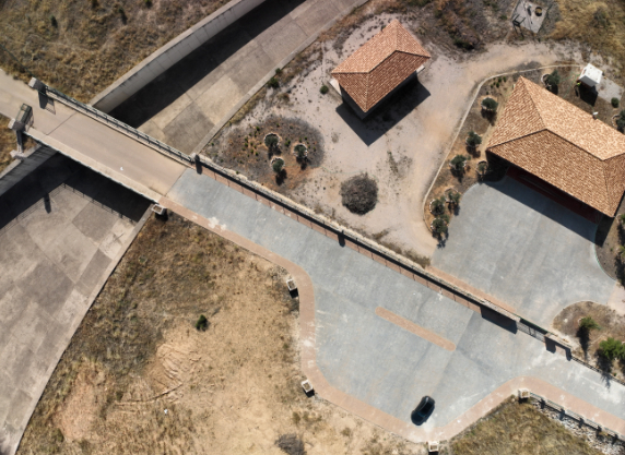
Drones
LiDAR scanning, high-definition aerial photography and video, as well as surveying, infrastructure inspections, and insurance claims.
GIS
Leveraging GIS (Geographic Information Systems) software to organize and analyze complex datasets and develop strategic spatial solutions.
LiDAR
Using LiDAR technology to create high-accuracy records for technical and engineering projects.
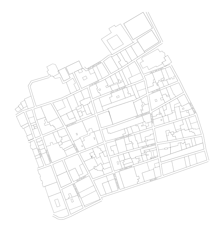
Cartography
Crafting intuitive and visually compelling custom maps tailored for brochures, publications, corporate presentations, and digital platforms.
Drones
At Mapatek, we integrate cutting-edge drone technology to capture spatial data with a level of precision and efficiency unattainable through traditional methods. We reduce project timelines and eliminate on-site risks, while consistently guaranteeing strict compliance with AESA regulations.
- LiDAR Surveys: High-density 3D modeling for dense vegetation and complex structures.
- High-Resolution Orthophotos: Detailed and up-to-date metric maps.
- Digital Models (DTM/DSM): Surface generation for flood studies, earthworks, and slope analysis.
- Inspection of Assets in Inaccessible Areas: The use of UAVs allows for infrastructure assessment without human exposure, scaffolding, or high-altitude work. Using LiDAR sensors and drones, we accurately identify structural pathologies and technical failures that would go unnoticed in traditional visual inspections.
- Construction Monitoring and Tracking: The implementation of digital twins and 3D models facilitates auditing actual progress against the original design (As-Built). This system enables early detection of geometric deviations, ensuring rigorous control over execution timelines and providing an objective technical basis for validating project certifications.
- Environmental Monitoring and Land Management: Through Digital Terrain Models (DTM) obtained with LiDAR, it is possible to perform multi-temporal analysis of changes in geomorphology and vegetation. These data, integrated into a GIS environment, enable efficient natural resource management, strict compliance with environmental regulations, and decision-making based on the actual reality of the terrain.
- Technical Evidence with Terrestrial and Aerial LiDAR: Generation of dense 3D point clouds to document the state of assets before and after an incident, allowing for exact temporal comparisons.
- Digital Modeling (DSM and DTM): Analysis of structural deformations, earth movements, or flooding through high-precision digital elevation models.
- High-Resolution Orthophotography: Visual documentation with sub-centimeter detail for identifying pathologies invisible to the naked eye.
- GIS Integration: We transform raw data into information layers for advanced spatial analysis.
- Legal Compliance: Operations under STS-01 standard scenarios, managing all necessary permits.
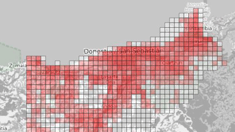
GIS
At Mapatek, we specialize in the technical inventory of assets, capturing on-site information through advanced positioning technology. We provide the essential database to ensure your management systems operate with real, geolocalized, and verified data, while also delivering the technical analysis required for its interpretation.
- Asset Inventory with GNSS: Location and technical cataloging of urban furniture, infrastructure, networks, and service elements using GNSS technology, ensuring centimeter-level positioning accuracy.
- Tree and Botanical Asset Surveys: Georeferencing and detailed characterization of vegetation, phytosanitary status, and technical parameters, ready for integration into green maintenance platforms.
- Drone-based Monitoring and Updates: High-resolution aerial image and data capture for the continuous update of territorial information, change detection, and rapid inventory of large-scale areas.
- Data for Technical Studies: Provision of digital models and spatial data for the generation of viewshed analysis, line-of-sight studies, and sun/shadow simulations.
- Baseline Information for Landscape Architecture: Delivery of detailed data on vegetation status and the surrounding environment, enabling architects and landscapers to determine species suitability based on scientific evidence.
- Cartography for Environmental Research: Generation of information layers regarding land-use changes and landscape fragmentation, providing physical evidence for environmental impact assessments.
- Drone-based Updates: High-resolution aerial data and orthophoto capture to ensure a consistently current and detailed cartographic base for the project area.
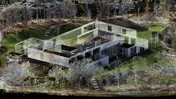
LiDAR
LIDAR technology obtains high-precision 3D mapping that allows the measurement of spaces and objects, the creation of metric panoramas, three-dimensional reproduction with point clouds and the generation of orthoimages. With the possibility of seeing and measuring each point, LIDAR is a tool that provides numerous solutions in architecture, engineering and design.
- Terrain Modeling (DTM): Thanks to the multi-return capability of the airborne sensor, we obtain the ground elevation in forested or densely vegetated areas where photogrammetry cannot reach.
- Power Lines and Infrastructure: Aerial capture of vertical assets, catenaries, and infrastructure corridors for safety clearance analysis and preventive maintenance.
- As-Built Surveys for Large-Scale Projects: Precise documentation of the actual state of execution in civil engineering, mining, or urban development projects, facilitating comparison with the original design.
- Building and Heritage Digital Twins: High-resolution scanning for the creation of detailed As-built models, capturing the exact geometry of facades, interiors, and historical artefacts.
- BIM Project Support: Provision of terrestrial point clouds ready for Building Information Modeling (BIM), ensuring that the design is based on measured reality.
Maps
Maps are a fundamental element of visual communication to transmit any type of spatial information. Through the maps, the relationship between objects, regions, themes or spaces can be visually synthesized, for example (points of interest, territorial limits, distribution of categories, characteristics of the earth’s surface…).
Mapatek’s goal is for a map to express spatial information clearly and be able to convey its visualization clearly. Among others, we do:
- Cartographic conceptualization of educational material
- Representation of parks, gardens and natural spaces
- Directional and informative plans for tourism or cultural events
- Expeditions, routes and trails
- Visual representation of scientific analyzes
- Heritage and natural maps
- Digitization and georeferencing of old maps
- Design of base maps for different projects and presentations